The Impact of Geography on Indian History
The Indian subcontinent is a well-defined geographical unit. It may be divided into three major regions: the Himalayan Mountains, the Indo-Gangetic Plains and the Southern Peninsula. There are five countries in the subcontinent – India, Pakistan, Bangladesh, Nepal and Bhutan. India is the largest among them and it comprises twenty-eight states and six Union Territories. According to the 2001 Census, the population of India is over one hundred crores.
The Himalayan Mountains
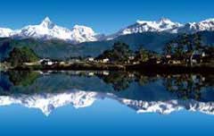
The Himalayan Mountains are situated on the north of India. Starting from the Pamir in the extreme northwest of India, the mighty Himalayan range extends towards northeast. It has a length of nearly 2560 kilometres with an average breadth of 240 to 320 kilometres. The highest peak of the Himalayas is known as Mount Everest with its height being 8869 metres. It acts as a natural wall and protects the country against the cold arctic winds blowing from Siberia through Central Asia. This keeps the climate of northern India fairly warm throughout the year. The Himalayan region is mostly inhospitable in winter and generally covered with snow.
 |
| The Himalayan Mountains |
Information related to the search:
The Impact of Geography on Indian History, india, history, passes, himalayan, mountains, geography, indian, indo, asia, impact, central, northwest, region, historical, time, routes, route, geographical, natural, situated, generally, kilometres, himalayas, subcontinent